Munter Calculation
- Backcountry Trip Planning Tool
- Skiing, mountaineering, hiking, climbing
- Calculate distance, time per leg, overall time
- Export to PDF, GPX and KML
- Save to site, share with friends and clients
About the Tool
( indicates premium feature requiring membership.)


- Point & click interface to add, move and delete points.
- Points automatically generate latitude / longitude, elevation, distance and bearings between points.
- Specify travel type (ski, hike, bushwack).
- Leg times and cumulative times calculated automatically based on distance, travel style and elevation gain/loss.
- Custom rates for travel styles for whole route, accomodates faster or slower groups.
- Custom rates for specific legs, accomodates faster or slower legs.
- Terrain, road map or satellite background maps.
- Search for locations to start your tour.
- Location aware, designed for all sized devices.
- Set preferences for decimal degrees, degrees decimal minutes, degrees minutes seconds or UTM.
- Save routes to site.
- Share link to saved route with anyone else.
- No membership required to view route through shared link.
- Load your saved routes into the planning tool.
- Generate list of all routes you've saved to your account; no remembering route names.
- Access saved routes from any device.
- Export routes to GPS, Google Earth or spreadsheet.
- Import waypoints from existing GPX or KML files; if you prefer plotting points in Google Earth, then save your plotted line as a KML file and import for trip planning.
- GPX files load into most standalone GPS', many apps on phones / tablets can display GPX files. Send GPX files to other trip participants.
- KML files open in Google Earth (on computers and mobile devices) allowing closer inspection of routes. Send KML files to other trip participants.
- CSV files open in Microsoft Excel and other spreadsheet programs (on computers and mobile devices) allowing further manipulation of raw data.
- Exported files include coordinates, elevation, bearings to next point, distances between points, transition times, times for legs and overall trip, custom notes for each points.
- Generate PDF file of entire route.
- PDF includes optional summary map, optional individual point maps, coordinates, elevation, bearings between points, distances between points, transition times, times for legs and overall trip, custom notes for each point.
- Save PDF's to computers, mobile devices for offline reference.
- Share PDF's by email, Facebook, Dropbox etc.
How It Works
What the Munter Calculation is
The Munter Method of Time Calculation was developed by Swiss guide Werner Munter. It allows you to calculate overall time for a tour based on distance
traveled, travel method, and elevation gain / loss. Using this method (including accurately accounting for rest/lunch breaks and time transitioning
between travel methods) you can predict how long a given tour will take.
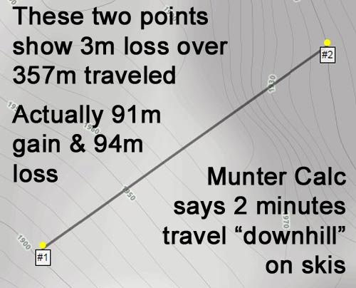
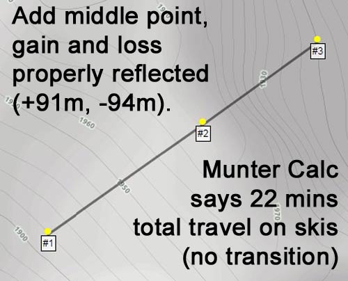
- For each leg, first you calculate a total number of "units"... each 1km of travel is 1 unit, and each 100m of elevation change (gain or loss) is 1 unit.
- The number of units for that leg is then divided by a "modifier", which varies depending on travel type and elevation gain/loss. Total units is divided by the modifier to number of hours to
complete that leg.
- The modifier varies depending on travel type and whether you are gaining or losing altitude.
- Modifiers in our system are adjustable either overall or leg by leg to accomodate different speed groups.
- Default modifiers in our system are:
CLIMBING: Walking: 4, Skiing: 4, Bushwacking: 2
DESCENDING: Walking: 6, Skiing: 10, Bushwacking: 2
- A simple example: You travel 2km while descending 200m on skiis: 2km = 2 units, 200m = 2 units. Total is 4 units. Skiing downhill has modifier of 10, so numbers of hours to complete travel is 4/10 = 0.4 hours or 24 minutes.
Premium Benefits
Why you should join
Basic features of the tool are free to the public:
However, by joining for $24.95 $14.95/USD/year you get these premium features:
- Build routes using point and click interface.
- View table depicting route, including latitude / longitude, elevation, distance between points, gain/loss between points, bearing between points.
- Customize trips by modifying either overall travel rate modifiers (for groups known to be faster or slower than normal), or leg by leg (for particularly easy or difficult legs)
- Add transitions and modify transition times, add notes for each leg.
- Advertising supported site.
However, by joining for $24.95 $14.95/USD/year you get these premium features:
- Save and load routes online; access your saved routes anytime from any device with just your login.
- Export routes you have created to GPX file (for use in standalone GPS's and mobile devices) for navigation in the field; GPX files can be shared with friends and trip participants.
- All pertinent data (lat/long, elevation, distance between legs, gain/loss, bearing, leg travel time, transitions and notes) embedded in GPX files to be viewed on GPS device.
- Export routes you have created to KML file (for use in Google Earth, either on computer or mobile device) for in depth investigation of route on Google Earth; KML files can be shared as well.
- All pertinent data noted in GPX files above is also embedded in KML files as well.
- Export/"print" routes you have created to PDF file for offline use; PDF files can be shared as well.
- PDF files contain overview map plus individual map for each point in route, as well as all pertinent route data noted above.
- Generate custom link for saved routes; share that link and anyone can pull up the route on this site to view in more detail.
- NOTE: Non members cannot generate KML/GPX or PDF files, but users who view a route using a shared link will be able to generate those files for themselves as long as they have not modified the route from its original form.
- Ad free for premium members.